Marine litter trajectories

Monitoring and highlighting marine litter accumulation and stranding zones in the North Atlantic waters.

In the aim of the iFADO project, NOVELTIS’ mission is to represent and monitor marine litter accumulation and stranding zones, thanks to multi-source earth observation data as well as an innovative modelling chain elaborated by NOVELTIS.
The iFADO project aims to create marine services at regional and subregional scales using the EU Atlantic Waters as case study. By filling current technical gaps, iFADO uses the european Marine Strategy Framework Directive (MSFD) implementation to demonstrate the application of innovative products. The project combines traditional monitoring with cost-effective, state-of-the-art technologies: remote sensing, numerical modelling and emerging observation platforms such us gliders and oceanic buoys.
NOVELTIS’ mission is to use remote sensing and novel earth observations methods to monitor and highlight marine litter accumulation and stranding zones. The goal is to produce user friendly indicators to assess the quality of water concerning marine litter.
In order to highlight marine litter stranding areas in coastal zones, it is relevant to take into account the tidal component of the oceanic current. However, global current data as Globcurrent or CMEMS global product (over the whole north-east Atlantic) don’t provide these components. NOVELTIS had to model and add this tidal component to global current data.
NOVELTIS - iFado simulation

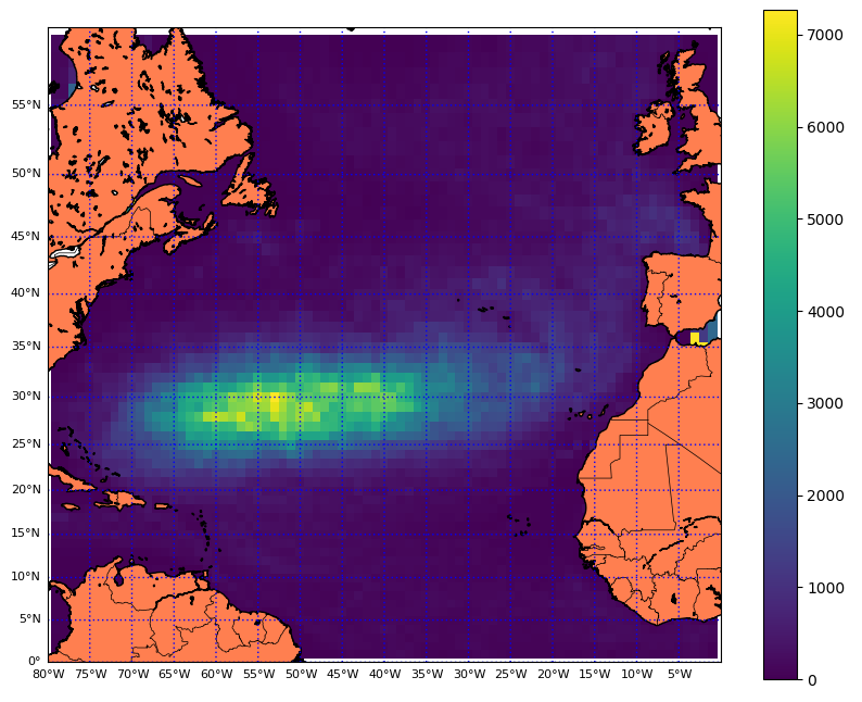
This plot represents the time spent (in days) by all the particles in a 0,5° longitude/latitude box, for a 4 year simulation. It evidences the accumulation and convergence (most time spent) in the middle of North Atlantic subtropical gyre.

Means used

  • Elaboration of an innovative lagrangian particles modelling tool
  • Integration in our model of global oceanic current data (e.g. Globcurrent, CMEMS) that we improve with tidal componant coming from NOVELTIS tidal Atlas products

RESULTS

Our marine litter modelling highlights a convergence of particles in the middle of the North Atlantic subtropical gyre. At a regional scale, one can observe an accumulation zone in the Bay of Biscay.
Main pathways are following the Canary Current and Azores current to join the accumulation zone in the subtropical gyre. Gulf Stream and North Atlantic drift take away some of the marine litter through the Atlantic Ocean to the European coasts and the Bay of Biscay.

Client / Partner(s)

The iFADO partnership, involving 20 partners, fosters the regional quadruple helix cooperation including public sector, university/research centres, enterprise and end-users to ensure that the designed products meet the market needs and are sustainable after the project lifetime.

Logo Interreg iFADO